


If something cannot go on forever, it will stop.
—Herb Stein
Preamble
This is me thinking out loud about some ideas linking ecology, fire dynamics, climate change, insurance, and economics. It mostly hangs together, but I wanted to put my ideas out in public, not wait until it was in perfect form, so it is less "tight" and more ruminative than usual.
If you don't want to read the whole thing, I CGPT-ed it for you, which misses a lot of the important stuff, but, hey, you be you.
🔥 Record Dryness: In California's Sierras, fuel moisture content has plummeted to record low levels due to persistent high heat, drastically increasing fire risks.
📉 Insurance Industry Response: Major insurers are withdrawing from the region due to soaring wildfire-related losses, rather than attempting to reprice policies amid prohibitive regulatory constraints.
Atmospheric Rivers, Then and Now
California is highly dependent on a few so-called "atmospheric river" events in winter for much of its snowpack, which in turn helps refill reservoirs and groundwater, as well as causing subsequent plant growth. The actual percentage of total water-year moisture varies somewhat from north to south, and from year to year, but, on average, nearly half of the state's annual precipitation comes from about a half dozen atmospheric river events during winter.
An atmospheric river is a flow of moisture off the Pacific Ocean that drops large amounts of moisture on the US west coast—rain at lower altitudes, immense snow at higher altitudes—almost always in winter. They can carry tremendous moisture flows, on average as much as the Mississippi River, but up to 10 times that in some cases.
California Water Years and Their Impacts
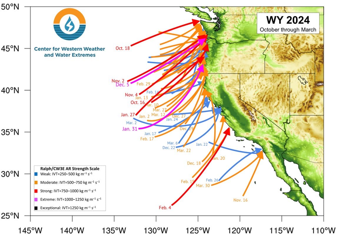
Here is a Scripps CW3E graphic of all the atmospheric rivers that made landfall in the western US this past winter. It was a little above average in terms of total precipitation.
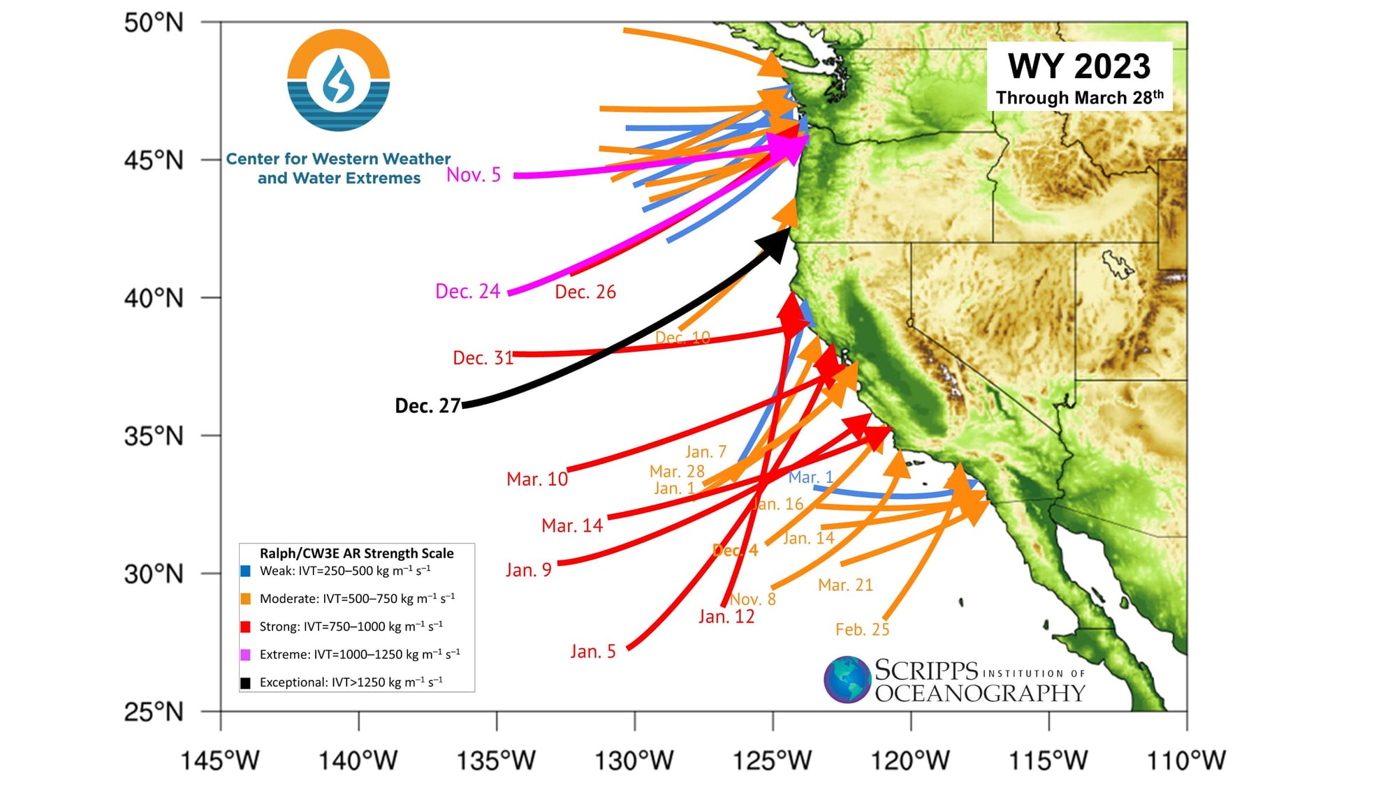
And here, by way of comparison, is the same graphic for the prior year, which produced record precipitation. The difference was two-fold: fewer but larger events than in the following year, and unusually cooler weather, causing more of the precipitation than usual to fall as snow.
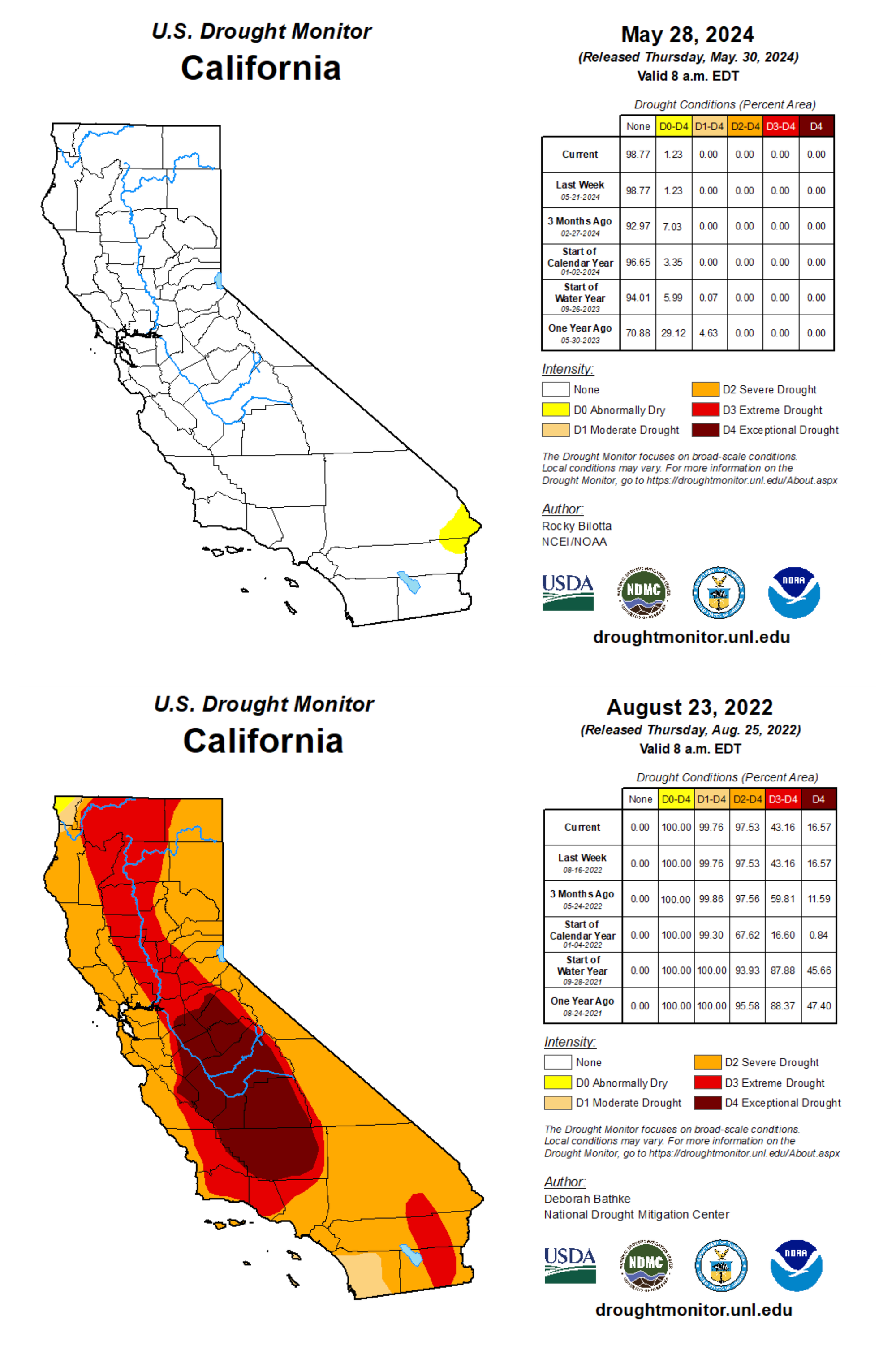
All of this moisture caused a reversal in California's long-term drought, which had covered the state. Consider the situation at the end of this past winter with that of late August of 2022, just before the record 2022-2023 storms. Where only a tiny portion of the state was still in (mild) drought a month ago, the entire state was two years ago, much of it extreme or even exceptional.
Recent research says we should expect more of these binary flips in the coming years, with periods of intense drought followed by record precipitation. This is a hallmark of a complex system seeking a new equilibrium, this oscillation between semi-stable states. We see it in classic predator-prey models in ecology, as well as in how landscapes, under pressure from repeated burning, can undergo a type conversion from, say, treed to grassland.
A predator-prey model is a mathematical representation of the interactions between two species: a predator and prey. It is often modeled as wolves, sheep, and grass. The most common model is the Lotka-Volterra, which consists of two differential equations. There are two stable equilibria: one with predator and prey in approximate balance, and one with both extinct. You can play with a simple model here.
In an energetic sense, you can think of an increasingly fuel-rich landscape as a predator-prey model with highly fertile fuels. A drier landscape provides more fuels faster, which leads to more fires, more of which are extreme. Eventually, however, the fuel landscape is transformed from trees to grasses, making regrowth faster, and fire starts more frequent.
We are seeing some of this in this year's data from Cal Fire. While fire starts are lower than average, the area burned is already well above average. This is in part because of higher-than-normal precipitation the past two winters, but it is more about a changing fuel landscape, one with more dried fuels, and more landscapes type-converting to fuels, like grasses, that grow faster and burn more readily.
To understand why, it helps to dive deeper in the nature of fuel and landscapes in a warming climate.
Your Friendly Neighborhood Napalm
To a certain kind of ecologist, landscapes look very different from how they do to you and me. We might look and see pretty trees, waving grasses, and berried bushes. They look at the same things and see DANGER DANGER DANGER.
Why? Because fire ecologists think about wildlands in terms of their fuel load, which is say how likely they are to burn, and how much energy will be released by doing so. That, in turn, is a function of how much dead, dying, and green vegetation there is, of which kinds, and of environmental conditions, like temperature, humidity, and wind. All of these factors, combined, are reduced to various measures, like 100-hour and 1000-hour fuel loads, ERC (energy release component), and so on.
Fuels: Anything that can burn, usually trees and shrubs. Dry things burn easiest.
100-hour fuel: Dead fuels, 1-3 inches in diameter.
1000-hour fuel: Dead fuels, 3-8 inches in diameter.
10000-hour fuel: Very large dead fuels, over 8 inches in diameter, slowest moisture content adjustment.
Live fuels: Living vegetation with high moisture content.
ERC: a calculated measure that considers the moisture content of different fuel classes (live and dead fuels of various sizes) and weather conditions.
None of these measures are static. Anything with vegetation (and many things without) can burn. The key is the stored energy, dryness, humidity, heat, wind, and the resulting pace at which they release energy when burning. In energy terms, a dried-out stand of timber, or a field of California chaparral, can burn with staggering intensity, on the order of tens of millions of BTUs per acre, which is up there with jellied gasoline used in warfare, also known as napalm.
And humans live willingly, if mostly obliviously, in these landscapes across the mountain west of the United States, as well as in parts of Spain, France, and Switzerland, even if at a smaller scale with less extreme fuel loads. But these landscapes are unstable, oscillating increasingly violently between semi-stable states that do not cancel each other out as climate warms. This shows up in recent work demonstrating that extreme wildfires are more common than ever in all geographies.
New work shows that what is happening is that the infrequent wetter winters are more than compensated for by hotter, dryer summers. This, in turn, pulls moisture from the vegetation via increased evaporative demand—or what some have taken to calling a "thirsty" atmosphere. A hotter, drier atmosphere is capable of drawing more moisture faster out of vegetation, thus increasing the stress on growing things, as well as increasing the risk of fires.
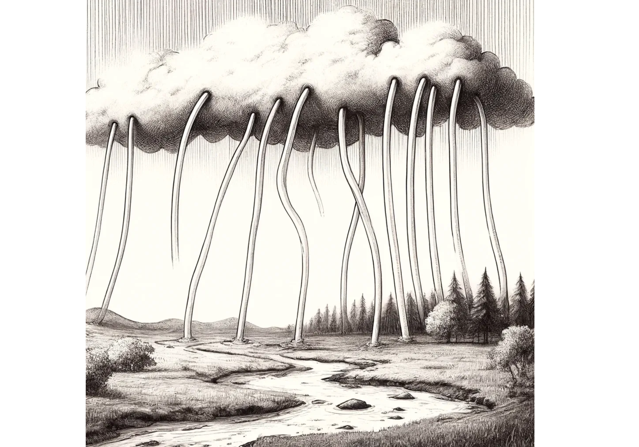
You can think of it as upward-flowing atmospheric straws pulling moisture from all parts of the landscape. There are more straws than ever, and they are getting fatter—and it is happening fast.
Combine Enough Straws and You've Got Yourself a River
In summer some moisture in reservoirs and vegetation evaporates into the atmosphere. This is basic thermodynamics, and the evaporative process is driven by heat & humidity. If you have cooler temperatures, there is somewhat less evaporation; higher temperatures and there is more.
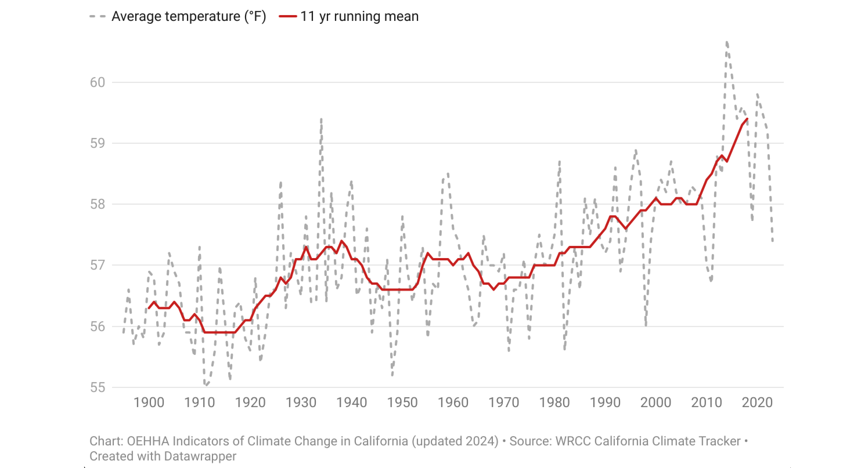
This evaporative process has accelerated in recent years. The most important factor: California's mean, statewide temperature has risen sharply over the last hundred years.
You can see the effect of sharply higher heat if we refocus the lens to this year. While the winter was slightly above average, leading to well above fuel moisture, the situation has now reversed completely. In California's Sierras, where the above normal heat has been persistent, touching record levels in recent weeks, the moisture content of fuels has collapsed, as the following graphß shows.
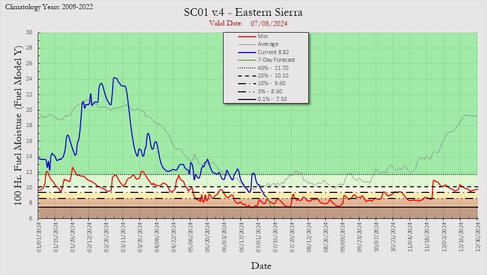
First, here is the Eastern Sierras, from Mount Whitney north to Lake Tahoe. Fuel moisture content was above average back in early April, and not far off as recently as mid-June, but has fallen sharply since then under persistent heat, now touching record levels of dryness.
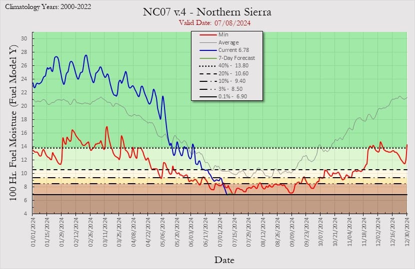
The situation is even more dramatic in the northern Sierras, where the current heat has been endless, setting daily, monthly, and all-time records. Again, the blue line shows that moisture content was around normal as recently late May, but it has collapsed since then, and is now at record low levels for the date.
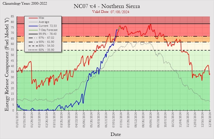
This is reflected in the ERC (energy release component) for the northern Sierra region, which is now at record levels, having hone straight up in recent weeks. Dried timber is now like napalm, ready to ignite and burn in extreme and uncontrollable blazes, as is already happening in various fires in the region.
A Future of Accelerating Upward Rivers
Let's think more analytically about what is happening. There is a vast amount of vegetation in the state, from chaparral and cactus to deciduous trees, to the coniferous forests of the Sierras (which have struggled mightily in recent years, losing millions of trees), to the photogenic giant Sequoias (where the losses have also been large in recent years). All this vegetation, living and dead, absorbs moisture during the winter, helping live vegetation grow while making it more difficult for dead vegetation to burn. The more dried the vegetation becomes, of course, the easier is to burn, and to do so intensely.
What has happened in the recent heatwave, however, is that a prodigious amount of moisture has exited the state's vegetation, and done so very quickly. How much and how quick? Using some reasonable assumptions based on moisture content, fuel density (live + 100-hour + 1000-hour), and the observed decline in fuel moisture, I conservatively estimate that approximately 40 billion liters of moisture has disappeared from vegetation in the last three months, most if it in the last month.
How much moisture is that? That is enough water to fill about 15,500 Olympic-sized swimming pools, or, in flow terms, a persistent river roughly the size of the Niobrara River in Nebraska—albeit upward-flowing into the atmosphere. It is a remarkable and persistent flow of moisture out of vegetation, one that, unlike a winter storm, cannot be seen, making its risk effects more insidious, even if it inevitably leads to even more fires through the West.
Unintended Consequences
Higher risks have consequences, even without immediate disasters. Among them is the insidious increase in costs associates with managing the risks associated with this increasingly fire-prone landscape.
For example, California now has nearly one hundred aircraft and hundreds of vehicles just to fight wildland urban fires. If it was a standalone force, it would be on par with the military of a small- to medium-sized country. These costs rise inexorably with population, sprawl, heat, and dryness, making the costs of climate change insidious and permanent, now over $150 billion a year.
Various studies now suggest that on a country, regional, and global level, the costs associated with dealing with climate change are already reducing GDP.
What Can Be Done?
Turning back to the fire problem, and the consequences of these reversing rivers, there are various ways to think through what is ahead. It helps, however, to start by thinking like an insurance company—risk and reward—so let's do that first.
Thinking Like an Insurance Company
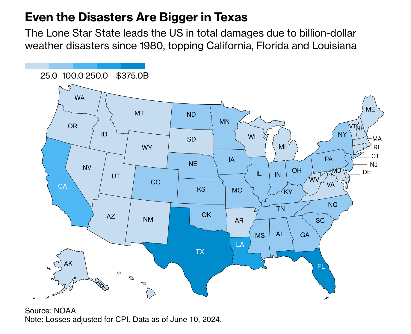
There will be more expensive insurable events in future. And it is worth noting that as much as I have focused on California here, it hasn't been the state with the highest consequences for insurance companies. That distinction belongs to Texas, followed by Florida, and only then comes California.
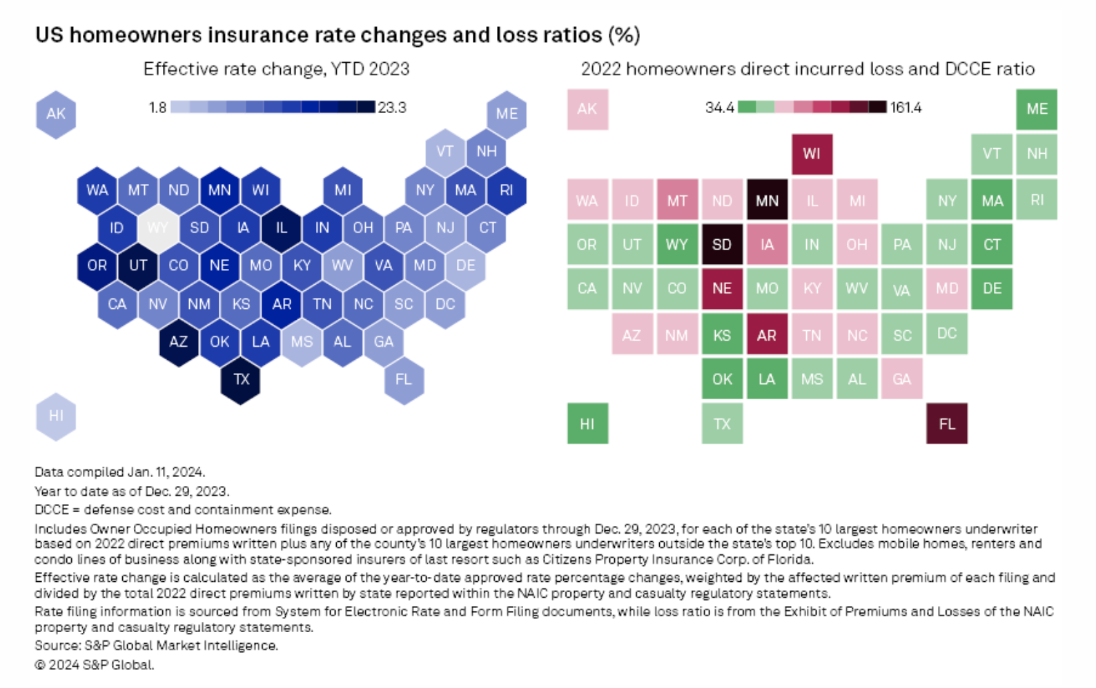
This rising risk has consequences with respect to insurance policy withdrawal and repricing. Consider the following S&P graphic to get a sense, where insured loss rates are, unsurprisingly, associated with insurance rate increases, even if it's not 1:1, especially given that insurance rises over time, not just because of a single event.
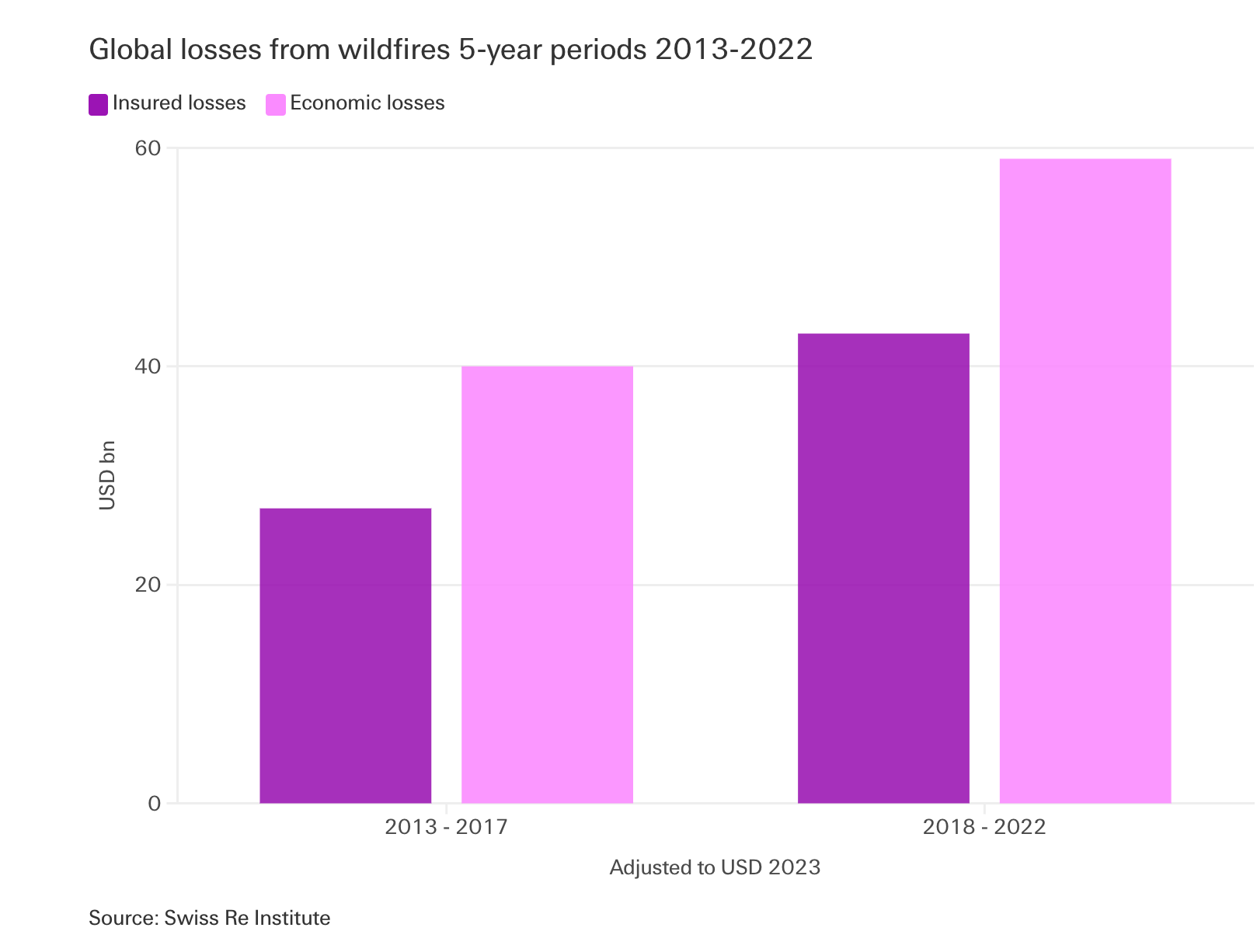
Turning back to California and fire risk, insurers are pulling back. As the following Swiss Re figure shows, global wildfire-related insured losses are soaring, and insurers are over-exposed to this risk, and California is among the larger regional causes.
Faced with this growing risk, insurers have only limited tools to deploy:
- They can reprice policies to try to "price in" the risk. This is often difficult to do, especially given the size of the rate increases that would be required. And even harder in states with a heavy regulatory presence, like California, where rate increases must be approved, which can take six to twelve months.
- They can cancel policies. This reduces risk exposure, but it requires a fine-grained understanding of risk, which still leaves insurers exposed. At the same time, it can open up investigatory and complaint windows, as consumers and regulators fight canceled policies.
- They can withdraw from the region. This is increasingly what has happened, with major insurers withdrawing altogether rather than repricing or selectively canceling policies.
Making things more complex for insurers is that local and regional governments have a tendency to change the insurance rules after an incident. Instead of encouraging people in frequently burned areas to move elsewhere, for example, they will often extend the window in which people can recover costs and rebuild, even if they choose to build elsewhere. These increase the risk of insuring such risks, while lowering forecast returns.
What might it look like in a more rational world? We would be having serious discussions about the kinds of thing we increasingly discuss in coastal regions, the idea of "managed retreat". In the coastal context it is about retreating from rising sea levels and coastal erosion. Inland, however, you can imagine a managed retreat from fire-prone regions, as the following piece discusses. Sadly, it seems unlikely, but the withdrawal of insurance coverage may change that.
How does the "sea-level rise" adaptation strategy of Managed Retreat transfer to enhanced-wildfires adaptation in California, or does it even? Two experts discuss pros and cons of managed retreat as a response to wildfire with @PPICNotes.https://t.co/RqcMCUYWie pic.twitter.com/KivcWt2V5W
— Mike Dettinger (@mdettinger) July 8, 2024
Conclusion
The interplay of atmospheric rivers, wildfire risks, and the escalating impacts of climate change presents a set of complex and dynamic challenges for California. The state's dependence on a few intense weather events for moisture, coupled with hotter, drier summers, increases the risk of severe wildfires. As vegetation loses moisture more rapidly, the potential for devastating fires increases, creating a volatile environment. Insurance companies, facing mounting losses, are reevaluating their exposure and reconsidering their presence in high-risk areas.
This situation demands a reassessment of risk management strategies, potentially including "managed" retreats from fire-prone areas of the state, and of entire countries, much like what is increasingly discussed in coastal regions.
Will it happen? For a long time, it seemed like it would not, but the withdrawal of insurance, reversing atmospheric rivers, increasing heat, and rising costs mean something must change, so it will. Things that cannot go on forever will stop.